After my last lesson, my instructor said I was ready to take the final skills test. I booked my test, and eagerly awaited the big day. T
For those of you who don’t know, a PPL skills test flight normally lasts between 2 and 2.5 hours, and consists of:
1. Navigation – before the flight, you’re given three waypoints and are asked to plan and fly the route. This is about testing your ability to safely plan and fly an appropriate route, using dead reckoning. Navigation aids are not allowed.
2. Diversions – you can expect never to reach the second planned waypoint, because on that second leg at some point the examiner will ask you to divert elsewhere. Here they’re looking for your ability to plan and execute a safe diversion – considering airspace, danger zones, restricted areas, etc along the way, as well as being able to estimate the correct heading and time required to get there. Oh, and your ability to draw the diversion line on the map – not easy trying to do that whilst flying a plane! Once you’ve reached the diversion destination, the examiner will take over responsibility for navigation and radio and ask you to perform a series of exercises….
3. General handling – you’ll be asked to demonstrate a bunch of general handling manoueveures, including: 3 x stalls (in clean configuration, in base leg configuration, whilst turning in approach configuration, and with drag flap); steep turns; spiral dive recovery
4. Emergency procedures – you’ll be asked to demonstrate a forced landing (your examiner will – at some random point – will cut the engine and you have to go through the motions of having a genuine engine failure); an engine failure after take-off (usually directly after the PFL)
5. IMC flight – the screens will go up (or the foggles go on) and you pretend you’ve inadvertantly entered IMC. Demonstrate what you’d do if it happened for real – eg consider OAT, MSA, rate 1 turn, potentially ask for radar service, etc.
6. Position fixing – after the IMC stuff, you’ll be asked to use any radio navigation equipment of your choice to identify your location on the map. Eg – VOR+DME, VOR+VOR, ADF+DME etc.
7. Radio homing – you’ll then be asked to home back to the airfield, negotiating your rejoin with the ATSU.
8. Circuits – normal, flapless, glide approach, performance landing, bad weather
So in the run-up to the day of the test, I had plenty to be revising!
The night before the test, I had a chat with the examiner, and he gave me a route to plan for the navigation part of the test. The test was booked for first thing in the morning, so this meant I could do most of the planning the night before, only needing to do the final bits of the PLOG in the morning when the weather forecast was available.
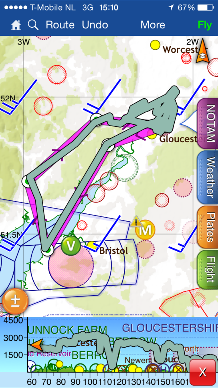
The route would be: Gloucester -> Clevedon Pier (VRP) -> Abergavenny -> Gloucester. You’re expected to use a direct route, and aren’t allowed to plan a route that would enable you to navigate by “feature crawling” – eg following a motorway or railway line. Drawing a straight line between Gloucester and Clevedon couldn’t give an easier journey, as you basically hug the shoreline all the way down. As it’s a pier, (and the first pier on the route) you would basically just keep going until you see the pier.
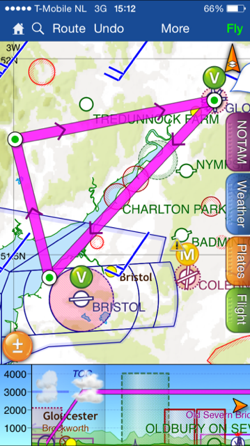
Alas, life is not that easy, because the direct route happens to cut directly through a bird sanctuary. Legally speaking, pilots don’t have to avoid these areas, but common decency and good airmanship would suggest you give them a wide birth, so I planned to divert around it.
I chose to divert to the west of the bird sanctuary. Partly because there is less in the way of restricted airspace and airfields, and partly because I was more familiar with that side of the estuary as I’d already done a lot of flying in the area whilst doing my navigation lessons. So, fly from Gloucester SSW to Cinderford, then fly direct to Clevedon. The first two thirds of the leg to Cinderford basically tracks above a railway line too, which would be useful to visually confirm I was on track (or enable me to make corrections to get back on track). And no, that doesn’t count as feature crawling!
Clevedon sits below the Bristol CTA (class D airspace), which starts at 1,500ft. So it would be critical for me to ensure I remained below their airspace, avoiding an incursion and a mandatory failure.
The Clevedon to Abergavenny leg has some nice ground features along the way, including the M4 J24 VRP and the reservoir to the north west. This leg is pretty much my home terriorty and I felt fairly comfortable about finding my way.
I didn’t spend much time planning or preparing for the third leg, as I knew we would have diverted by then. Instead, I tried to second-guess where I might be asked to divert from and to, thinking through the various scenarios. It’s fairly safe to assume you’ll be diverting back towards the airfield rather than away from it, so that narrows it down somewhat.
To prepare for the route, I did a bit of research using Google Earth. You can ‘fly’ the route, which is really useful as it helps you to identify visual clues on the ground with the chart. I also flew the route using Xplane, which was unnecessary but helped keep my mind occupied during the run-up to the big day!
The morning of the exam, and the weather forecast was looking ok. High enough cloud base, and 10km visbility, with no frontal systems to worry about. However, by the time I arrived at the airfield, I could see the weather wasn’t as good as had been forecast. Visibility was poor, with lots of mist. I met my examiner, we had a quick friendly chat before going in to ‘test mode’. First, we had the pre-flight briefing. I talked him through the planned route, my PLOG, the weather forecast, the fuel planning, flight performance figures for take-off and landing distance as well as the NOTAMs and temporary airways. He seemed happy that I had decided to avoid the bird sanctuary and was happy with everything I’d planned.
Next, he asked me some questions. Firstly, he asked me to explain the meaning of this symbol on the chart:
I answered “it shows the extended centreline of runway 09”, which clearly was only a small part of the answer he was looking for. So I said “but let me just double-check the legend and I’ll confirm whether it has any other significance too.” He was happy for me to do that, and soon enough I told him it signified an instrument approach procedure in uncontrolled airspace. So yes, whilst it was the extended centreline, this was the more significant answer, and the one he was looking for. Next question…
<points to the big blue numbers on the chart> – “what does this mean?”, he asked. “Well”, I said, “that’s the Maximum Elevantion figure for that section – it gives you a quick and easy way to see the highest point, which you can add 1,000ft if you’re in a hurry to to get an MSA”. We talked about it some more, and he was happy – he said he was looking to make sure I knew that it wasn’t the MSA, but the maximum height, which you can then use to calculate the MSA.. So, another right answer.. So far, so good..
He then talked through what would happen in the flight, and read out a series of statements that described what would and wouldn’t happen, and what to expect in various situations – for example, no emergencies are planned on the navgation part of the route, so if something does happen, proceed as if it is a genuine emergency.
He then gave me an hour to prepare the airplane (it needed an A-check) and fuel it, so I set off and checked everything over. I taxied down to the pumps and filled up with fuel, then got back to the apron. In the ten minutes I’d gone, the apron had filled up with planes – busier than I’d ever seen it – and I was only just able to park up clear of the line. Luckily some chaps were about to give me a hand moving everything around, making space and then finally helping me turn my aircraft around so I’d be pointing the right way at the start of the test. Worked up a bit of a sweat!
Whilst all this had been happening, I hadn’t noticed the weather had taken a turn for the worse. Before, whilst hazy, I could see May Hill to the West of the airfield, which is 10nm away. By now, I couldn’t see it at all – everything was suddenly very hazy, and there was no visible horizon. Doh.
I went back inside and talked with a couple of guys who had just landed. “Poor visibility”, they reported, “and it seems to be getting worse”. We weren’t in any rush, so my examiner was happy to wait and see if things improved. After an hour, things were worse, and there was no sign of things getting better. I said (ultimately it was my decision, they can not tell you whether to fly or not based on the weather – that’s part of what they’re testing you on!) that we’d have to call it a day and reschedule, and the examiner seemed pleased that I’d made the right decision. Really annoying, but what can you do!?
Several days of high pressure and slow wind didn’t do much to change the situation, before finally the forecast showed there could be a gap in a couple of days. I phoned the examiner – he was available – and we re-booked the test.
On the day, this time the weather stayed good, and as we had already completed most of the pre-briefing stuff last time, we had a quick recap before I went out to A-check the plane. (It was already full). We were on.
Sat in the left hand seat, I was working through my checklist as normal. At the “pasenger safety brief” item, I asked the examiner if he’d like it, and he said yes. The checklist has a standard paragraph that covers it, so I read it out (for the first time) and he was happy, so I carried on as usual. So far so good.
I obtained the ATIS and called Gloucester Tower to request taxi. The examiner booked us out using his callsign (Aeros 56) with Tango at the end to signify test, so today we were Aeros 56 Tango. Runway 04 was active – I’d only ever departed from this once – so I started the long taxi down to the holding point, where I stopped to run through the power and pre-take-off vital checks. “Ready for departure”, I said, followed by clearance to take off. This was it – here we go!
After passing Staverton village (for noise abatement), I made a climbing left turn to get on our initial heading. As we passed abeam the runway, I hit start on the stopwatch and filled out the ETA column on the PLOG. Gross error checks suggested we were heading in the right direction, and I could see the railway line so I knew we were on track.
I levelled off at at 2,300ft to stay clear of the cloud base. Top of climb FREDA check complete, then just a couple of minutes until we were overhead Cinderford, our first turning point. Everything was going to plan.
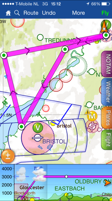
We were now heading directly towards the Pier, albeit with about 20minutes before we got there – so no sign of it yet. However, along the way we’d pass to the right of both Severn Bridges, and directly overhead Chepstow, which all provided helpful clues that we were on track. As I approached the old Severn Bridge, I changed frequency to Bristol Radar and told them we would be descending to 1,3000ft and requested a basic service. They gave us a squawk and I started the descent.
Cruising over the Severn felt a little weird at first, as I’d not flown over water before. I started to wonder whether I should have talked about life jackets in the pre-brief, or whether it’d have been better to route to the East after all, but it was too late for that now – I had to concentrate on flying! We were now down at 1,300ft on Bristol’s QNH and Avonmouth Docks were to our left. I could see a pier straight ahead of us – woohoo – and we were on time, too. When we were overhead, I turned right on to the next heading and we flew towards Newport. After a couple of minutes, we were safely outside Bristol’s airspace so I climbed up to 2,500ft. Visibility was great, and I could easily see the M4 J24 VRP and the Reservoir VRP beyond that.
Diversion time. As I pointed out that I was happy we were on track due to the reservoir being ahead of us, the examiner said to plan a diversion from the Reservoir to Ross On Wye. Excellent, I thought, as I was familiar with the area and had also practiced this exact diversion route when considering the possible options in preparation for my test.
Line drawn, true converted to magnetic, corrected for wind, heading calculated, distance measured and time calculated. I planned the diversion from directly overhead the reservoir, so I flew us towards it, waited to get overhead, then turned and started the stopwatch. I told the examiner the heading and estimated time of arrival, then talked through the hazards on route. Usk gliding site was reason to keep an extra good lookout, but apart from that were was nothing notable along the route.
One minute later than estimated, we were overhead Ross On Wye, with its distinctive church and the start of the M50 motorway. The examiner announced the navigation section was over, and that he’d now take charge of navigation and the radio. Phew! I had a big sigh of relief and enjoyed a celebratory polo mint!
After a minute or so to recompose myself, we started with the general handling section of the test. First up was steep turns. After completing a HASEL check, I started with a 45 degree turn to the left. All good. Next up, a HELL check, followed by a 60 degree turn to the right. All good. Next!
Then we did stall recovery. First up, I was asked to develop a full stall in the clean configuration and to recover on his command. All went to plan. For the next set of stalls, I had to recover at the first sign of the stall – eg when the stall warner starts sounding. Everything went well. Then the examiner took control, and put the aircraft into a sprial dive. I had to recover on his command. He waited until we got pretty close to VNE and you could really feel the G force. “Recover”, he announced, so I moved the throttle back to idle and rolled the wings level. Airspeed under control, power back on and I initiated a climb back to 3000ft. All good.
Next up, we ‘accidently entered IMC’ (well, I had to wear a pear of Foggles – foggy goggles!) so I had to do a 180 degree Rate One turn out of there. We were already above MSA, and the outside air temperature was well aboving freezing so no other actions were necessary. Immediately after completing the 180 degree turn, the examiner again took control and we flew for a couple of minutes. He then asked me to identify our position on the chart.
Using the Gloucester NDB and DME, I marked (after tuning and identing) our position on the chart, shown it to the examiner, who then said to take the foggles off. Sure enough, we were about 0.5nm away from where I had marked, which was good enough.
We then had an engine failure, and as we were 3,000ft I had plenty of time to run through the drill. Trim for 73, turn downwind and pick a field (I chose one on my left), then talked through my “Whats Up” checks. (Simulated) radio call made, then shutdown checks, followed by a turn for left base before turning on to final. At about 300ft AGL I was told to climb away, only to have an Engine Failure After Take Off (EFATO) shortly afterwards. I picked a field within 30 degrees of our heading, nose down for 73 and was told to climb away. All good.
Finally, I had to use the ADF to home back to the airfield, negotiating my rejoin on the radio with Gloucester Approach. As I had previously been using the NDB for the position fixing, I was already tuned and idented, so I could simply twist the OBS knob to my heading and then fly the heading shown. We were 6nm from the airfield, so I quickly obtained the ATIS and made the radio call requesting a rejoin.
Runway 04 was active, with a left hand circuit. Exactly the same as when we departed. By this time, we were 3nm and handed to Tower. This is where I started to go wrong… Maybe it was because I was getting tired (we’d been flying for just over 2 hours by this point), or maybe it was because I was rushing (I’d normally start planning the join from 10nm out – having the same work condensed in to 3nm is always going to be a squeeze), but whatever the reason, I messed up.
In my head, I had completely messed up the picture of the airfield and my overhead join. An overhead join for 04 should involve approaching the airfield, keeping it on your left hand side, and flying around it until you’re above the 04 numbers. Then, descend on the deadside to cross 22 at 1,000 ft, then you’re crosswind, ready to turn downwind, then base, then final for 04. Easy, obvious and a procedure I’ve done loads before without any problems. However, in the heat of the moment, I crossed the 22 numbers and started my descent, descending on the live side. What an idiot! Instead of doing an overhead join for 04, I did one for 22!
It wasn’t until I had descended to 1,000ft that I realised what I’d done. I told Tower I was mis-positioned and would climb out of the zone so I could reposition for another overhead join.
I climbed to 2,000ft and flew north for a couple of miles, straight and level. I wanted to regain my composure and explained to the examiner what I was doing. He was happy for me to do that, so after a couple of minutes I was speaking with approach again and negotiating my overhead join for 04. At 3nm I was handed back to tower, and this time I correctly joined overhead for 04, executing a good approach and touch and go.
Next up, I had to do a flapless approach. It went well. Then it was time for a glide approach. Again, went well. Finally, it was time for a bad weather circuit so after taking off I started a climbing turn to 500ft for an extra-close downwind leg. It all seemed to work out ok, so I was pretty quickly taxing off the runway and performing the landing checks. I then taxied back to the Apron and shutdown.
“I’m sorry to say you’ve failed”, those immortal words!
I knew I’d failed the moment I realised I had done the wrong join, but I suppose there was always a small part of me optimistacally hoping that I might still squeeze in a pass. No such luck. We went back inside and had a coffee, before debriefing.
He’d been really pleased with my navigation and general handling, and everything was looking good for a pass until I messed up the join. It was a mandatory fail item and there was nothing anyone could do about it. However, there was light at the end of the tunnel.
The reason he’d asked me to continue with the circuits was so that I could get what’s called a partial pass. The skills tests is divided in to several sections, and each section is passed or failed. By successfully passing every section except one, the positive way of looking at it was I had a “partial pass”. To get a full pass, I’d simply need to book another test and re-do the bit I messed up. That test only needs to consist of a departure, leaving the ATZ, then performing an overhead join with a succesful landing. I wouldn’t have to do everything else again.
Whilst this was good news, I still felt pretty crappy about the whole thing and went home feeling really annoyed at myself. I just couldn’t believe I had managed to mess up an overhead join – something so bloody simple!
Bad luck on the partial. I know how it feels. It would have been great to finish it in one go but I am sure that you will complete it easily. You are so much more accomplished than I was when I passed. Best wishes. David
I’m inspired by all the work and pre-planning you did for this test, and even more inspired that there was a small part of the test which you failed. There’s hope and success, even after failure. Makes me less nervous and stressed about my own test.
Got my skills test this week – was so bad at navigation but have that sorted now.. just thinking of it all over and over – I won’t forget a pee first and to bring a small bottle of water!
I’m hoping to start my PPL trianing in the new year (at Gloucester), so nice to hear about your test despite the outcome. I’m sure by now you’ve passed and have many happy hours under your belt.